1 (888) 9-HYDREX    [email protected]
Hydrex Hydrex Drone Division
1 (888) 9-HYDREX    [email protected]

GIS Mapping Solutions

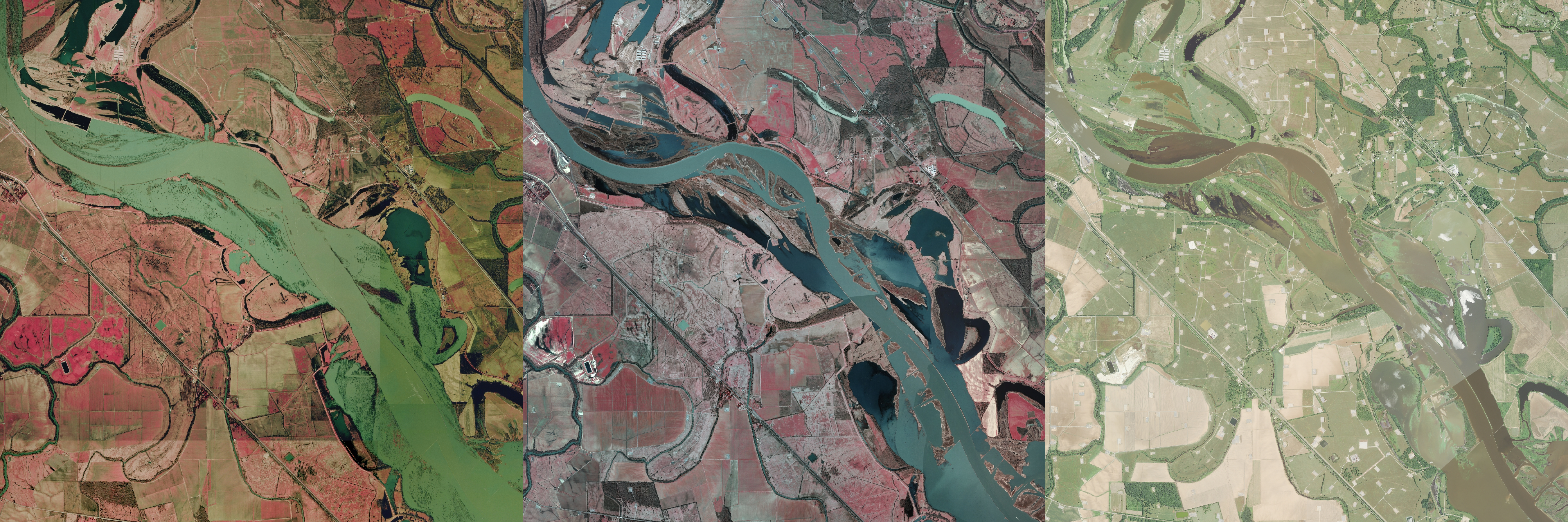
Hydrex Geographic Information System (GIS) mapping enables us to present projects using cutting-edge technology. Online interactive mapping solutions, three-dimensional subsurface and groundwater modeling, and watershed analysis are among a number of the GIS mapping services we offer.

Hydrex GIS Consulting and Solutions include:

  • Map packages for report submitting or planning –From small format figures in reports to large-format poster prints for planning and presentations, Hydrex will make sure your maps look professional and convey the meaning behind the data.
  • GIS data compilation, management, and analysis – Pulling from a multitude of sources, Hydrex can compile a large variety of data (from imagery and topography to infrastructure and utilities) to provide you with comprehensive analysis suited to your needs.
  • GPS field data collection and post processing –With a wide arsenal of field-deployable tools, such as mapping-grade GPS units and aerial drones, our experienced and certified field crew  provides accurate and thorough insights into every site we visit.
  • Technical expertise and creative problem solving –Our experienced GIS staff is always available for consult, and we can provide a strong dynamic solution to any problem with creative use of GIS and mapping.
  • Aerial photograph interpretation and stereoscopic analysis – Hydrex has the experience and resources to interpret natural-color, color-infrared, or multispectral imagery. Using processing software, or time-tested stereoscopes, we provide a full 3-D perspective, too.


HYDREX ENVIRONMENTAL | Established 1994
312 Old Tyler Rd., Nacogdoches, TX 75961
Toll Free: 1 (888) 9-HYDREX
(936) 568-9451 | [email protected]
Satellite Office: Houston, Texas
Serving clients throughout the United States. Licensed in Texas, Louisiana, Arkansas, Mississippi, Alabama, Tennessee, Georgia, and Florida.